The Village Green Before the Postcard
See how a village green’s position can reveal shared history, changing uses and the settlement’s shape, then read it thoughtfully on a village walk.
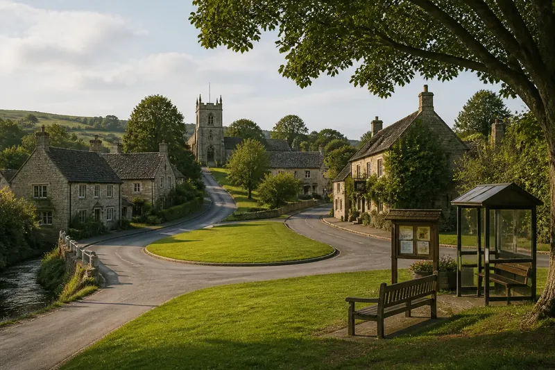
A village green can explain a village’s shape before its signboard explains its name. On a walk through a British village, notice where the open ground sits in relation to the oldest-looking lanes, cottages, church, pub and stream; its position may reveal how a shared space once helped organise daily life.
Read the green as part of the settlement
Greens are not all the same kind of place. Some lie at a crossroads, where paths from farms and neighbouring settlements meet; others stretch along a main street, occupy a gap between rows of houses, or sit beside a church or former manor. Each position gives a different clue about how people reached and used the space.
A central green can suggest that the settlement grew around an open common area. A green at the edge may have served people arriving from the surrounding countryside, or may simply have been left as the village expanded. A stream, slope or road junction can also help explain why open ground remains in one particular spot.
These are clues, not a formula. Later building, road changes and land division can alter the pattern, so compare the green with the surrounding layout rather than treating its position as a complete account.
Imagine a walk that changes what the green means
Imagine arriving in the invented village of Aldercombe on foot from a lane that descends between pasture fields. At the entrance, a small green lies beside a road fork. There is a bus shelter on one edge, a noticeboard near a bench, and cottages facing the grass. The visitor initially reads it as a tidy centre made for visitors to pause.
Instead of crossing straight to the pub, the visitor walks around the edge and looks outward from each corner. One lane climbs toward the church, another follows the stream, and the road ahead continues toward newer houses. The open space is not simply a scenic centre: it sits where several everyday journeys converge.
At the noticeboard, a local event advertises a village gathering on the green. The visitor does not assume that this explains the site’s whole history, but it does show that the place still has a shared use. The bench and shelter serve ordinary arrivals, while the open ground can accommodate an event without being divided into private plots.
On the return leg, the visitor takes the church lane and sees older cottages facing the same open space. The green now reads as a hinge between routes and buildings, not a decorative patch left over for a postcard. Its location connects the village’s lanes while keeping a common area visible and accessible.
That invented walk offers a useful method: look at the green from its approaches, then ask what movement and gathering its position makes possible.
Shared ground has changed with village life
A green’s role can shift as local needs change. It may have been used for grazing, informal meetings, games, celebrations or practical access, with different activities sharing the same ground at different times. A surviving open space can carry traces of those layers even when its present use is quieter.
Look for signs of current activity without treating any one feature as proof of the past. A worn path across grass suggests regular passage; a noticeboard or bench points to present-day use; a village sign may describe local identity. Together, these details show how the green functions now, while the surrounding roads and building fronts help you consider why it occupies that place.
The green may also have become more formal. Mown edges, planted beds or a memorial can shape how people gather, while still leaving the space open. Rather than deciding that a managed green has lost its communal role, notice which parts invite people to pass through, sit, meet or watch village activity.
Position reveals connections, not a fixed origin
Compare the green’s edges with the village’s routes. A path that cuts across it may link two streets more directly than the road around its perimeter. A lane narrowing at one end can suggest that the green has long been a point where movement slows or divides. Nearby buildings can show whether homes, civic places or businesses orient themselves toward the space.
Also notice what lies just beyond the apparent centre. A church set slightly apart, a stream forming a boundary, or newer houses extending along one road may indicate that the settlement grew unevenly. The green can remain central to village life even if it is no longer the geometric middle.
Do not infer ownership or public access from appearance alone. Where access, use or historical status matters, check the village information board or ask an appropriate local source rather than crossing a boundary on assumption.
What can a village green tell you?
Why is the green beside a road junction?
A junction can bring together routes from farms, neighbouring villages and different parts of the settlement, making open ground useful for meeting or pausing. The layout may have changed over time, so look at the lanes and buildings together before drawing a conclusion.
Does a central green mean the village grew around it?
It may suggest that the open space helped organise the settlement, but a present-day centre can also result from later building or road changes. Compare older-looking streets, churches and streams for a more grounded reading.
How can I tell whether the green is still shared?
Notice ordinary signs of use, such as paths, seating, a noticeboard or an event announcement. Treat these as evidence of current activity, not proof that every visitor may use every part in every way.
Should I walk across the grass?
Follow visible paths and posted guidance, and avoid walking through a gathering or event. If access is unclear, stay on the public route and ask locally rather than assuming the open appearance means unrestricted entry.
Let the walk test your first impression
For a useful village-green reading, pause at the approaches, trace the routes that meet nearby, and check which buildings face the open ground. Then look for present-day signs of gathering or passage, keeping observed details separate from guesses about the past.
In Aldercombe, the invented visitor’s first impression gave way to a more useful one: the green joined paths, homes and shared activity at a natural meeting point. On your next village walk, the position of the green may tell you more than its neat borders do; take one extra turn around it before moving on.